The Colorado River has carved its way through mountains, canyons and arid terrain for nearly six million years. The river is 1,450 miles long and drains into seven U.S. states and into parts of northwest Mexico (5). The monumental river is is the predominant river of the southwest and runs from the central Rocky Mountains, through the Colorado Plateau, and bends south as it reaches the Arizona-Nevada border.
The Colorado River Basin supplies water for 30 million people in Denver, Las Vegas, San Diego, Los Angeles, Phoenix, Salt Lake City and Albuquerque. It provides irrigation for 3.5 million acres of fruits and vegetables which generate $1.5 billion per year. In Mexico the river flows into a large delta, draining into the Gulf of California (1).
 |
| Map showing the entire river, and the seven U.S. states it runs through Source: http://media.smithsonianmag.com/images/Colorado-River-Map-20.jpg |
History
Paleo-Indians are thought to have started dwelling around the Colorado River basin 12,000 years ago. Later, Meso-Indians would dominate the human population of the watershed. These groups of people were hunter gatherers and mostly hunted small to medium sized mammals, and gathered plants. The Fremont people from Utah began living around the basin 2,000 years ago. They are the first humans to have used the river for agriculture (2).
During the first few centuries A.D., large agricultural societies had developed. By 600 A.D. the Hohokam people developed large-scale irrigation systems that proved to be more vast and efficient than those of any other native group around the Colorado River (3). The Hohokam built hundreds of miles of irrigation canals shooting off of the River basin, specifically the Salt River and the Gila River. These canals currently lie underneath the city of Phoenix, Arizona. These canal systems were capable of irrigating up to 250,000 acres of land (4). These canals and methods of irrigation were much more sustainable than the ways in which the river is used today. However, indigenous peoples' irrigation networks caused damage to the rivers and were not entirely sustainable either. They over excavated many of these canals turning them from shallow creeks into large brooks which in turn became a hinderance to their agriculture. In the 14th century a drought quickly wiped out all of the native groups surrounding the basin (3).
In the 16th century Spanish explorers embarked on parts the Colorado River in search of gold (7). Many of these explorers were among the first non native people to see the Grand Canyon. Francisco de Ulloa is the first explorer to document his voyage up part of the river from the Gulf of California (6).
Protected Areas:
Bibliography:
(1) Berg, Linda R., Mary Catherine. Hager, and David M. Hassenzahl. Visualizing Environmental Science. 3rd ed. Hoboken, NJ: Wiley, 2011. Print.
(2) Grahame, John, Keith G. Pohs, Thomas D. Sisk, and Charles Van Riper. "People and Land Use on the Colorado Plateau." People and Land Use on the Colorado Plateau. CPLUHNA, n.d. Web. 20 Nov. 2013. <http://cpluhna.nau.edu/People/people.htm>.(3) Water History. 2012. WaterHistory.org. Web. 19 November 2013.
(4) Glenn, Edward P., Karl W. Flessa, and Jennifer Pitt. "Restoration Potential Of The Aquatic Ecosystems Of The Colorado River Delta, Mexico: Introduction To Special Issue On “Wetlands Of The Colorado River Delta”." Ecological Engineering 59.(2013): 1-6. Academic Search Complete. Web. 25 Nov. 2013.
(5) William S. Abruzzi. The Social and Ecological Consequences of Early Cattle Ranching in the Little Colorado River Basin. Human Ecology , Vol. 23, No. 1 (Mar., 1995), pp. 75-98.
(6) Meyers, Charles J. The Colorado River. 1st ed. Vol. 19. N.p.: Stanford Law Review, 1966. Web. 20 Nov. 2013. <http://www.jstor.org/stable/1227048>.
(7) "Geological Survey: John Wesley Powell's Exploration of the Colorado River." National Park Service. USGS Science for a Changing World, 28 Mar. 2006. Web. 20 Nov. 2013. <http://www.cr.nps.gov/history/online_books/geology/publications/inf/powell/sec2.htm>.
(8) Society, N. 2013. Freshwater Resources -- National Geographic. 20 November 2013. <http://environment.nationalgeographic.com/environment/freshwater/freshwater-resources/>.
(9) Underhill, A. Heaton, A. Busa Xaba, and Ronald E. Borkan. "The Wilderness Use Simulation Model Applied to Colorado River Boating in Grand Canyon National Park, USA." Environmental Management 10.3 (1986): 367-74. Print.
(10) American Rivers. 2013. America's Most Endangered Rivers for 2013 - Colorado River. Web. 20 November 2013. <http://www.americanrivers.org/endangered-rivers/2013-report/colorado/>.
Mcbride, P. 2010. The Colorado River Runs Dry. Web. 20 November 2013. <http://media.smithsonianmag.com/images/Colorado-River-Map-20.jpg>.
Salt River Project. n.d. Canals of the Salt River Valley. Web. 20 November 2013. <http://www.waterhistory.org/histories/hohokam2/>.
Didonato, G. and Moore, C. 2011. Big Dams and Park Resources: Water Management in the Colorado River Basin. Fort Collins, CO: Center for Park Research. NPCA. PDF File. 20 November 2013. <http://www.georgewright.org/1114didonato.pdf>.
State of the Park - Grand Canyon National Park. 2010. Washington, DC: National Park Conservation Association. NCPA. PDF File. 20 November 2013. <http://www.npca.org/about-us/center-for-park-research/stateoftheparks/grand_canyon/GRCA-report.pdf>.
The Colorado River Runs Dry. n.d. National Geographic. PDF File. 20 November 2013. <http://environment.nationalgeographic.com/environment/freshwater/freshwater-resources/>.
During the first few centuries A.D., large agricultural societies had developed. By 600 A.D. the Hohokam people developed large-scale irrigation systems that proved to be more vast and efficient than those of any other native group around the Colorado River (3). The Hohokam built hundreds of miles of irrigation canals shooting off of the River basin, specifically the Salt River and the Gila River. These canals currently lie underneath the city of Phoenix, Arizona. These canal systems were capable of irrigating up to 250,000 acres of land (4). These canals and methods of irrigation were much more sustainable than the ways in which the river is used today. However, indigenous peoples' irrigation networks caused damage to the rivers and were not entirely sustainable either. They over excavated many of these canals turning them from shallow creeks into large brooks which in turn became a hinderance to their agriculture. In the 14th century a drought quickly wiped out all of the native groups surrounding the basin (3).
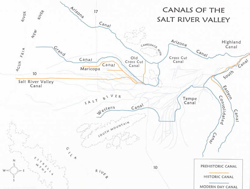 |
| Map indicating the history of irrigation canals in the Salt River Valley Source: http://www.waterhistory.org/histories/hohokam2/map1.jpg |
 |
| Two Mohave men by the Colorado River, 1871. Source: http://www.archives.gov/research/native-americans/pictures/select-list-136.html |
Protected Areas:
There are five dams in the main stem of the Colorado River that are protected, including the Hoover Dam and Glen Canyon Dam. In addition to these dams, many National parks, such as the Grand Canyon National Park are protected. The status of these protected areas, however, are grim. The Hoover Dam provides lots of hydro-electric power and stops flooding, but also disrupts the river course. This disruption inevitably devastates fish populations and contributes heavily to the decline of the estuarine ecosystem. The Glen Canyon Dam is located in a place where the effects of water loss and silt retention are greater and worse than other places. Grand Canyon shows the deterioration of wildlife and environment from the lack of funding and staff as well as the external threats outside of the power of local officers.

Hoover Dam:
The Hoover Dam was constructed during the great depression and is located between Nevada and Arizona, creating the reservoir: Lake Mead. However, its construction contributed to destroying the local ecosystem, altering the water flow, and erosion/pollution. The construction of the dam lowered the riverbed below it by 4 meters, which endangers plant species that can no longer reach the water. This in turn disturbs the gentle balance of the ecosystem, endangering local dependent wildlife. Even thought the dam was created to lower fossil fuel usage, the dam itself is a source of massive amounts of greenhouse gases. Lastly, the pure surface area of Lake Mead accelerates evaporation and tampers with the chemistry of the water.

Likely Future:
"Climate projections show that predicted higher temperatures are likely to result in shorter winters, earlier spring runoff, increased evaporation, and a future reduction of Colorado River stream flow and water supplies. The dark blue area represents the average annual volume of water in million acre-feet during the period from 2003-2007." (8)
The river is projected to dry up in the next 50 years due to booming populations in the surrounding major cities, increased demand and consumption, and climate changes. In the attempt to prevent the projected consequences from actually occurring, Mexico and the United States are working on legislation to increase protection, reservation, and restoration of the Colorado River.

Human Impact:
The human impact on the Colorado River is very bad. Over the years, the demand for water has drastically impacted the river system as well as the environment of the Colorado River. From irrigation diversions to diking to channelization and pollution, humans have destroyed the natural state of the river and have completely departed many sections of the main river. The most visible effect of human impact is the irrigation return with silt and chemical pollutants.

How to Maintain People-Ecosystem Balance:
1. Donate to the various protection and restoration foundations.
2. Dams need to be regulated and updated. Do not completely remove water from the river.![]()
3. Further increase regulation on recreational use, such as motor-boating. With the help of Lake Powell, control the stream of water to emulate Colorado River's natural flow. (9)
4. Have surrounding industries and farms instal own irrigation systems to use less of Colorado River's water.
5. For all dams, canals, and pipelines, analyze the distribution of water to minimize droughts and over-allocation which stress reservoirs and water storages.
6. Help restore water levels to counter-balance the rise in heat levels and drop in precipitation rates.
7. “Support robust and effective funding levels for the Bureau of Reclamation’s WaterSmart and Title XVI Water Reclamation and Reuse programs. These programs help stakeholders to optimize existing water infrastructure, maximize available water supplies, and provide healthy river flows for communities and ecosystems. Support cost-effective investments in existing water supply infrastructure, and ensure that operations of existing storage can efficiently maximize water delivery in reliable quantities. Prioritize funding for water efficiency and conservation programs. Ensure that funding promotes the protection of rivers by directing management decisions that maintain and restore flows needed for river health in critical areas of the Basin.” (10)

Glen Canyon Dam
Source: National Geographic
Hoover Dam:
The Hoover Dam was constructed during the great depression and is located between Nevada and Arizona, creating the reservoir: Lake Mead. However, its construction contributed to destroying the local ecosystem, altering the water flow, and erosion/pollution. The construction of the dam lowered the riverbed below it by 4 meters, which endangers plant species that can no longer reach the water. This in turn disturbs the gentle balance of the ecosystem, endangering local dependent wildlife. Even thought the dam was created to lower fossil fuel usage, the dam itself is a source of massive amounts of greenhouse gases. Lastly, the pure surface area of Lake Mead accelerates evaporation and tampers with the chemistry of the water.

The Hoover Dam
Source: http://www.hdrinc.com
Likely Future:
"Climate projections show that predicted higher temperatures are likely to result in shorter winters, earlier spring runoff, increased evaporation, and a future reduction of Colorado River stream flow and water supplies. The dark blue area represents the average annual volume of water in million acre-feet during the period from 2003-2007." (8)
The river is projected to dry up in the next 50 years due to booming populations in the surrounding major cities, increased demand and consumption, and climate changes. In the attempt to prevent the projected consequences from actually occurring, Mexico and the United States are working on legislation to increase protection, reservation, and restoration of the Colorado River.

Human Impact:
The human impact on the Colorado River is very bad. Over the years, the demand for water has drastically impacted the river system as well as the environment of the Colorado River. From irrigation diversions to diking to channelization and pollution, humans have destroyed the natural state of the river and have completely departed many sections of the main river. The most visible effect of human impact is the irrigation return with silt and chemical pollutants.

The Colorado River Delta today
Source: National Geographic
How to Maintain People-Ecosystem Balance:
1. Donate to the various protection and restoration foundations.
2. Dams need to be regulated and updated. Do not completely remove water from the river.
3. Further increase regulation on recreational use, such as motor-boating. With the help of Lake Powell, control the stream of water to emulate Colorado River's natural flow. (9)
4. Have surrounding industries and farms instal own irrigation systems to use less of Colorado River's water.
5. For all dams, canals, and pipelines, analyze the distribution of water to minimize droughts and over-allocation which stress reservoirs and water storages.
6. Help restore water levels to counter-balance the rise in heat levels and drop in precipitation rates.
7. “Support robust and effective funding levels for the Bureau of Reclamation’s WaterSmart and Title XVI Water Reclamation and Reuse programs. These programs help stakeholders to optimize existing water infrastructure, maximize available water supplies, and provide healthy river flows for communities and ecosystems. Support cost-effective investments in existing water supply infrastructure, and ensure that operations of existing storage can efficiently maximize water delivery in reliable quantities. Prioritize funding for water efficiency and conservation programs. Ensure that funding promotes the protection of rivers by directing management decisions that maintain and restore flows needed for river health in critical areas of the Basin.” (10)
Bibliography:
(1) Berg, Linda R., Mary Catherine. Hager, and David M. Hassenzahl. Visualizing Environmental Science. 3rd ed. Hoboken, NJ: Wiley, 2011. Print.
(2) Grahame, John, Keith G. Pohs, Thomas D. Sisk, and Charles Van Riper. "People and Land Use on the Colorado Plateau." People and Land Use on the Colorado Plateau. CPLUHNA, n.d. Web. 20 Nov. 2013. <http://cpluhna.nau.edu/People/people.htm>.(3) Water History. 2012. WaterHistory.org. Web. 19 November 2013.
(4) Glenn, Edward P., Karl W. Flessa, and Jennifer Pitt. "Restoration Potential Of The Aquatic Ecosystems Of The Colorado River Delta, Mexico: Introduction To Special Issue On “Wetlands Of The Colorado River Delta”." Ecological Engineering 59.(2013): 1-6. Academic Search Complete. Web. 25 Nov. 2013.
(5) William S. Abruzzi. The Social and Ecological Consequences of Early Cattle Ranching in the Little Colorado River Basin. Human Ecology , Vol. 23, No. 1 (Mar., 1995), pp. 75-98.
(6) Meyers, Charles J. The Colorado River. 1st ed. Vol. 19. N.p.: Stanford Law Review, 1966. Web. 20 Nov. 2013. <http://www.jstor.org/stable/1227048>.
(7) "Geological Survey: John Wesley Powell's Exploration of the Colorado River." National Park Service. USGS Science for a Changing World, 28 Mar. 2006. Web. 20 Nov. 2013. <http://www.cr.nps.gov/history/online_books/geology/publications/inf/powell/sec2.htm>.
(8) Society, N. 2013. Freshwater Resources -- National Geographic. 20 November 2013. <http://environment.nationalgeographic.com/environment/freshwater/freshwater-resources/>.
(9) Underhill, A. Heaton, A. Busa Xaba, and Ronald E. Borkan. "The Wilderness Use Simulation Model Applied to Colorado River Boating in Grand Canyon National Park, USA." Environmental Management 10.3 (1986): 367-74. Print.
(10) American Rivers. 2013. America's Most Endangered Rivers for 2013 - Colorado River. Web. 20 November 2013. <http://www.americanrivers.org/endangered-rivers/2013-report/colorado/>.
Mcbride, P. 2010. The Colorado River Runs Dry. Web. 20 November 2013. <http://media.smithsonianmag.com/images/Colorado-River-Map-20.jpg>.
Salt River Project. n.d. Canals of the Salt River Valley. Web. 20 November 2013. <http://www.waterhistory.org/histories/hohokam2/>.
Didonato, G. and Moore, C. 2011. Big Dams and Park Resources: Water Management in the Colorado River Basin. Fort Collins, CO: Center for Park Research. NPCA. PDF File. 20 November 2013. <http://www.georgewright.org/1114didonato.pdf>.
State of the Park - Grand Canyon National Park. 2010. Washington, DC: National Park Conservation Association. NCPA. PDF File. 20 November 2013. <http://www.npca.org/about-us/center-for-park-research/stateoftheparks/grand_canyon/GRCA-report.pdf>.
The Colorado River Runs Dry. n.d. National Geographic. PDF File. 20 November 2013. <http://environment.nationalgeographic.com/environment/freshwater/freshwater-resources/>.